


iStreetImage app for iPhone and iPad
Developer: Industrial Technology Research Institute (ITRI)
First release : 15 Aug 2009
App size: 886.73 Kb
iStreetImage is an iPhone client for Web service "StreetImage.tw" which provides contiguous street images of user contributed trails. Users can search trails by keyword and follow the track to have a city tour. So far, only streets in Taiwan were covered including a variety of urban streets and country roads. With iPhones video recorder, users can make their own trials, upload and share to the public.
Have a go with keyword Taipei_101 to get a list of trails around the Taiwans highest building.
Features:
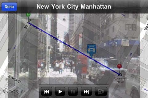
1.Show a Specific Trail on the Map
2.Play Contiguous Street Images of a Specific Trail
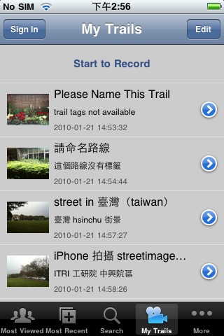
3.Get Most Viewed Trail List
4.Get Most Recent Trail List
5.Search Trail by Keyword
6.Manage a Personal Favorite List
Features added in ver. 0.9.3:
1.More trails are returned after a search. Pagination is enabled with 15 trails per page.
2.Don’t need to play a trail from the beginning. Hold down to drag the ‘CAR’, drop it to a specific position and play the trail from there.
Features added in ver. 0.9.4:
Make trails, upload and share!!!
1. Now you can use iPhone to capture video for the street(trail) you want to contribute.
2. Edit your newly captured trail(name it, add tags or description).
3. Upload your trails and share to the public(recommend). The more people share, the higher street coverage is.
Newly uploaded trails could be found in the Most Recent list after processing.
You will need:
1. iPhone(to capture video).
2. Turn on Location Service to allow iStreetImage to know your location while recording.
3. A free account for uploading trails.
Web Service Portal: http://streetimage.tw/
===
iStreetImage© 是服務 StreetImage.tw 的 iPhone 版本。該服務能將使用者貢獻的街道影片拆解成一張張的街景照片,並且依照地理位置顯示於地圖上,進一步分享給其他朋友。 iStreetImage 目前能以關鍵字搜尋所有公開路線,並直接瀏覽沿線的街道景色。到目前為止只有台灣中北部城市、鄉村的街道有較高的涵蓋率。非常期盼您也能利用新的拍攝、上傳功能貢獻一些屬於您的私房路線。
現在不妨嘗試一下搜尋關鍵字:台北101。讓 iPhone 帶您去台灣最高樓附近壓壓馬路吧!
功能:
1.將特定路線顯示於地圖上
2.播放連續的街景圖
3.取得"最多觀看次數"的路線清單
4.取得"最新加入"的路線清單
5.以關鍵字搜尋路線(可根據標籤、路線名稱、貢獻者ID、細部描述或是所有關鍵字進行搜尋)
6.管理個人喜好清單
0.9.3 版新增功能:
1.現在能以分頁得到更多的搜尋結果,每頁15條。
2.現在不必再每次都重頭播放街景。可以任意搬動地圖上的”目前位置”(壓住後搬移),並從指定位置開始播放。
0.9.4 版新增功能:
拍攝、上傳、分享
1. 現在您可以使用iPhone 拍攝自己想要紀錄的路線
2. 編輯自己所拍攝的路線(命名您的路線,增加標籤及細部描述)
3. 上傳您拍攝的路線與其它人分享(建議公開)。愈多人貢獻,街景涵蓋率就高
上傳的影片將拆解成一張張的街景照片,您可以在"最新加入"的路線清單中找到它
您將需要:
1. 有錄影功能的 iPhone
2. 拍攝時允許開啓定位服務
3. 取得 streetimage 帳號(免費)以便上傳路線影片
服務官網: http://streetimage.tw/
Latest reviews of iStreetImage app for iPhone and iPad
Nice program if Canada gets covered
Its useful in Taiwan. We need more areas.